On-the-ground updates from our Stewardship team
We thought it was well overdue to check in with our Stewardship staff, who work each day to care for our protected lands. From wildfire recovery to grazing, our Stewardship team has stayed busy the last several months.
Wildfire recovery and adaptation
For landowners who have experienced wildfires on their properties, we ensure they have the resources they need to help their land recover and adapt. Weeks Ranch (both north and south), was completely burned by the Glass Fire – that’s over 1,200 acres of protected land! Our staff have been working closely with the landowners to observe and document the site right after the fire, to perform a specific post-fire evaluation, and then to support the landowners in longer-term cleanup and preparedness work.
During post-fire evaluations, we assess and document initial fire effects across a representative selection of plant communities and forest types, fire severity classes, and topography. This location-specific information is provided to the landowner along with corresponding photographs, a broader discussion of the fire’s overall ecological impacts to the property, and notes and recommendations regarding post-fire management that may be called for, such as suppression impact repair, fuel management, and invasive species control.
At our Calabazas Creek and Saddle Mountain Open Space Preserves, which we currently own and manage, we’ve continued fire stewardship and adaptation work.
At Calabazas Creek, we have continued recovery work from the 2017 Nuns Fire with vegetation management through sheep grazing and workdays, and the implementation of shaded fuel breaks. To create shaded fuel breaks, we worked with Cal Fire and the California Conservation Corps to thin and remove more flammable understory (lower to the ground) vegetation while leaving the majority of larger, more fire-adapted tree species in place. This work was funded by a Fire Prevention Program grant from Cal Fire.
At Saddle Mountain (read more about the impacts of the 2020 Glass fire on this property here), we’ve been working with Cal Fire and local contractors to reduce berms (raised soil) from firebreaks created during firefighting work, remove sediment from creeks, and clean up toxic waste at a burned structure site. We’ve been working with PG&E and local contractors to assess and remove hazardous trees along roadways that were burned beyond recovery. We have also done work to reduce the risk of erosion, and are continuing to analyze other areas in and adjacent to the preserve for additional erosion risks.
To make sure these lands are healthy and prepared for future wildfire seasons, we plan to carry out a grassland prescribed burn at Calabazas, and implement shaded fuel breaks, forest understory thinning, and follow-up prescribed burning on Saddle Mountain.
Restoration and grazing
Beyond wildfire recovery and preparedness work, we’ve also been focusing on restoration projects and lots of grazing across several properties we own and protect.
At our Oken property, we worked with Point Blue Conservation Science’s STRAW (“Students and Teachers Restoring a Watershed”) program on native plant revegetation. Over a series of four workdays, students worked along the property’s riparian corridors to plant live oak acorns, buckeyes, willows, rushes and sedges, and other native species to help stabilize and revegetate these areas. More restoration and additional plantings of native plants to come this summer!
We also set up grazing operations at Haroutunian South and part of SF Archdiocese. Grazing on these properties helps to reduce invasive species that impede the growth of native plants, while also helping to reduce fire hazard. Below are before and after grazing photos of Haroutunian South! To further our work on Haroutunian South, we’ll be partnering with the Laguna Foundation in the coming months to monitor and enhance rare plant populations.
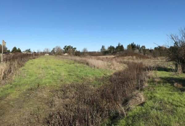
Before grazing at Haroutunian South.
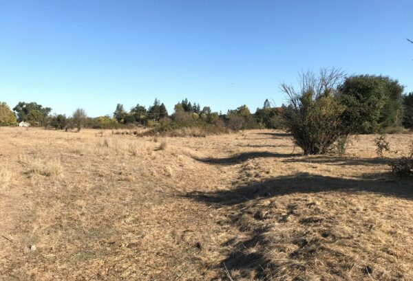
After grazing at Haroutunian South.
Data collection and long-term planning
To become even more efficient in our conservation easement monitoring, we’ve started to use the Collector app, which is an ArcGIS tool for field data collection. This way, when our staff are out in the field, the app will directly upload all the data we’re capturing, rather than staff having to manually enter the information into a database later.
We’ve also completed several outstanding baseline reports for open space easements that that were added to our portfolio through County development work. Baselines are in-depth snapshots of an easement property’s condition, which provides the foundation for how we monitor the land long-term.
As we start to turn the Vital Lands Initiative into action, our stewardship team is going to be an integral part of how our protected lands continue to thrive for many years to come!