September 24, 2019
Posted in: News Articles
Vegetation mapping + fire resiliency
Recently, Ag + Open Space’s Allison Schichtel and Karen Gaffney spoke with NASA for their “A Partnership Forged by Fire” story about our vegetation mapping efforts, and how the data are being used today to plan and prepare for the future.
Well before the 2017 Sonoma Complex Fires, Ag + Open Space partnered with Sonoma Water to create the Sonoma County Vegetation Mapping and LiDAR Program, or “Sonoma Veg Map” for short, a multi-year program to map Sonoma County’s topography, physical and biotic features, diverse plant communities, habitats, and agricultural lands. These data are foundational to our land conservation mission, helping the organization to prioritize its land protection investments. Funded in part by a $1 million grant from NASA to the University of Maryland for the acquisition of countywide LiDAR, the program has produced more than 30 publicly available imagery and data products.
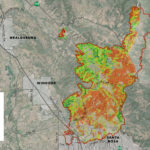
In March 2018, Ag + Open Space received an additional $90,000 from NASA as part of the Rapid Response and Novel Research in Earth Science Program. This grant funded the capture of aerial imagery of areas burned in 2017. The aerial imagery was used to map canopy damage of trees and tall shrubs, and to produce a 2017 Sonoma Complex Fires story map that takes a deeper dive into the Pocket, Tubbs, and Nuns fires.
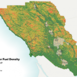
The analysis of the pre- and post-fire datasets has enabled the mapping of “ladder fuels” throughout the county and an assessment of the role of these ladder fuels in burn severity. Ladder fuels are shrubs, small trees, and other vegetation with heights of 3 to 13 feet that can increase the likelihood of fire spread. The areas with more ladder fuel prior to the fires were some of the areas most affected in 2017. With current mapping of fuel loads, County planners are able to prioritize where and when potential fuels should be treated – especially when paired with detailed maps that show locations of homes, hospitals, and critical exit routes. Key partners in the ladder fuel analysis include Tukman Geospatial, Kass Green & Associates, and the Pepperwood Preserve.
While this mapping work directly supports fire resiliency planning, it also helps with long-term decision-making at Ag + Open Space and for partner agencies and groups throughout the County. Currently, the countywide vegetation and land use maps are being used to:
- Focus and prioritize land conservation efforts toward healthy, connected plant communities and wildlife habitats that protect our native biodiversity
- Protection of watersheds, streams and wetlands that support clean, abundant water for people and wildlife
- Assess climate mitigation and adaptation strategies and benefits provided by the landscape, such as the amount of carbon sequestration in forests or the degree to which riparian areas, floodplains, and coastal habitats may buffer extreme weather events
- Track changes over time to Sonoma County’s habitats and natural resources as a result of human activity or conservation efforts
This work would not have been possible without the following partners: Sonoma Water, California Department of Fish and Wildlife, the United States Geological Survey, the County of Sonoma Information Systems Department, the County of Sonoma Transportation and Public Works Department, NASA, and others.

